GNSS World of China
GNSS World of China
| Citation: | ZHENG Zhiqing, ZHANG Kefei, LI Longjiang, SHI Jiaqi, ZHANG Minghao. Performance evaluation of atmospheric precipitable water vapor inversion of mutil-system GNSS at selected MGEX stations[J]. GNSS World of China, 2022, 47(5): 100-110. doi: 10.12265/j.gnss.2022119

|

| [1] |
WANG J H, ZHANG L Y, DAI A G, et al. A near-global, 2-hourly data set of atmospheric precipitable water from ground-based GPS measurements[J]. Journal of geophysical research:atmospheres, 2007, 112(D11): D11107. DOI: 10.1029/2006JD007529
|
| [2] |
BEVIS M, BUSINGER S, HERRING T A, et al. GPS meteorology: remote sensing of atmospheric water vapor using the Global Positioning System[J]. Journal of geophysical research:atmospheres, 1992, 97(D14): 15787-15801. DOI: 10.1029/92jd01517
|
| [3] |
张卫星. 中国区域融合地基 GNSS 等多种资料水汽反演、变化分析及应用[D]. 武汉: 武汉大学, 2016.
|
| [4] |
姚宜斌, 张顺, 孔建. GNSS 空间环境学研究进展和展望[J]. 测绘学报, 2017, 46(10): 1408-1420. DOI: 10.11947/j.AGCS.2017.20170333
|
| [5] |
王朝阳, 周兴华, 卢勇夺, 等. 中国沿海地基 GPS 水汽反演精度分析[J]. 大地测量与地球动力学, 2016, 36(12): 1060-1063.
|
| [6] |
董佩明, 赵思雄. 边界层过程对“98·7”长江流域暴雨预报影响的数值试验研究[J]. 气候与环境研究, 2003, 8(2): 230-240. DOI: 10.3878/j.issn.1006-9585.2003.02.10
|
| [7] |
万蓉, 郑国光. 地基 GPS 在暴雨预报中的应用进展[J]. 气象科学, 2008, 28(6): 697-702. DOI: 10.3969/j.issn.1009-0827.2008.06.019
|
| [8] |
楚艳丽, 郭英华, 张朝林, 等. 地基 GPS 水汽资料在北京“7·10”暴雨过程研究中的应用[J]. 气象, 2007, 33(12): 16-22. DOI: 10.7519/j.issn.1000-0526.2007.12.003
|
| [9] |
李国翠, 李国平, 连志鸾, 等. 地基 GPS 水汽资料在石家庄一次暴雨过程中的应用[J]. 气象与环境科学, 2007, 30(3): 50-53. DOI: 10.3969/j.issn.1673-7148.2007.03.011
|
| [10] |
CHEN B Y, LIU Z Z. Analysis of precipitable water vapor (PWV) data derived from multiple techniques: GPS, WVR, radiosonde and NHM in Hong Kong[C]//China Satellite Navigation Conference (CSNC), 2014: 159-175. DOI: 10.1007/978-3-642-54737-9_16
|
| [11] |
BOONE C D, WALKER K A, BERNATH P F. Speed-dependent voigt profile for water vapor in infrared remote sensing applications[J]. Journal of quantitative spectroscopy and radiative transfer, 2007, 105(3): 525-532. DOI: 10.1016/j.jqsrt.2006.11.015
|
| [12] |
LU C X, FENG G L, ZHENG Y X, et al. Real-time retrieval of precipitable water vapor from Galileo observations by using the MGEX network[J]. IEEE transactions on geoscience and remote sensing, 2020, 58(7): 4743-4753. DOI: 10.1109/TGRS.2020.2966774
|
| [13] |
郭秋英, 侯建辉, 刘传友, 等. 基于北斗三号的大气水汽探测性能初步分析[J]. 全球定位系统, 2021, 46(1): 89-97,111. DOI: 10.12265/j.gnss.2020090802
|
| [14] |
WANG X M, ZHANG K F, WU S Q, et al. The correlation between GNSS-derived precipitable water vapor and sea surface temperature and its responses to El Niño–Southern Oscillation[J]. Remote sensing of environment, 2018(216): 1-12. DOI: 10.1016/j.rse.2018.06.029
|
| [15] |
LI H B, WANG X M, CHOY S, et al. Detecting heavy rainfall using anomaly-based percentile thresholds of predictors derived from GNSS-PWV[J]. Atmospheric research, 2021(265): 105912. DOI: 10.1016/j.atmosres.2021.105912
|
| [16] |
HÉROUX P, KOUBA J. GPS precise point positioning using IGS orbit products[J]. Physics and chemismistry of the earth, part A:solid earth and geodesy, 2001, 26(6-8): 573-578. DOI: 10.1016/S1464-1895(01)00103-X
|
| [17] |
SAASTAMOINEN J. Contribution to the theory of atmospheric refraction[J]. Bulletin gæ odésique, 1972, 105(1): 279-298. DOI: 10.1007/BF02521844
|
| [18] |
HOPFIELD H S. Two-quartic tropospheric refractivity profile for correcting satellite data[J]. Journal of geophysical research, 1969, 74(18): 4487-4499. DOI: 10.1029/jc074i018p04487
|
| [19] |
BLACK H D. An easily implemented algorithm for the tropospheric range correction[J]. Journal of geophysical research:solid earth, 1978, 83(B4): 1825-1828. DOI: 10.1029/JB083iB04p01825
|
| [20] |
吴旭祥, 郭秋英, 侯建辉. 基于BDS精密星历产品的水汽探测性能分析[J]. 全球定位系统, 2019, 44(5): 91-99. DOI: 10.13442/j.gnss.1008-9268.2019.05.014
|
| [21] |
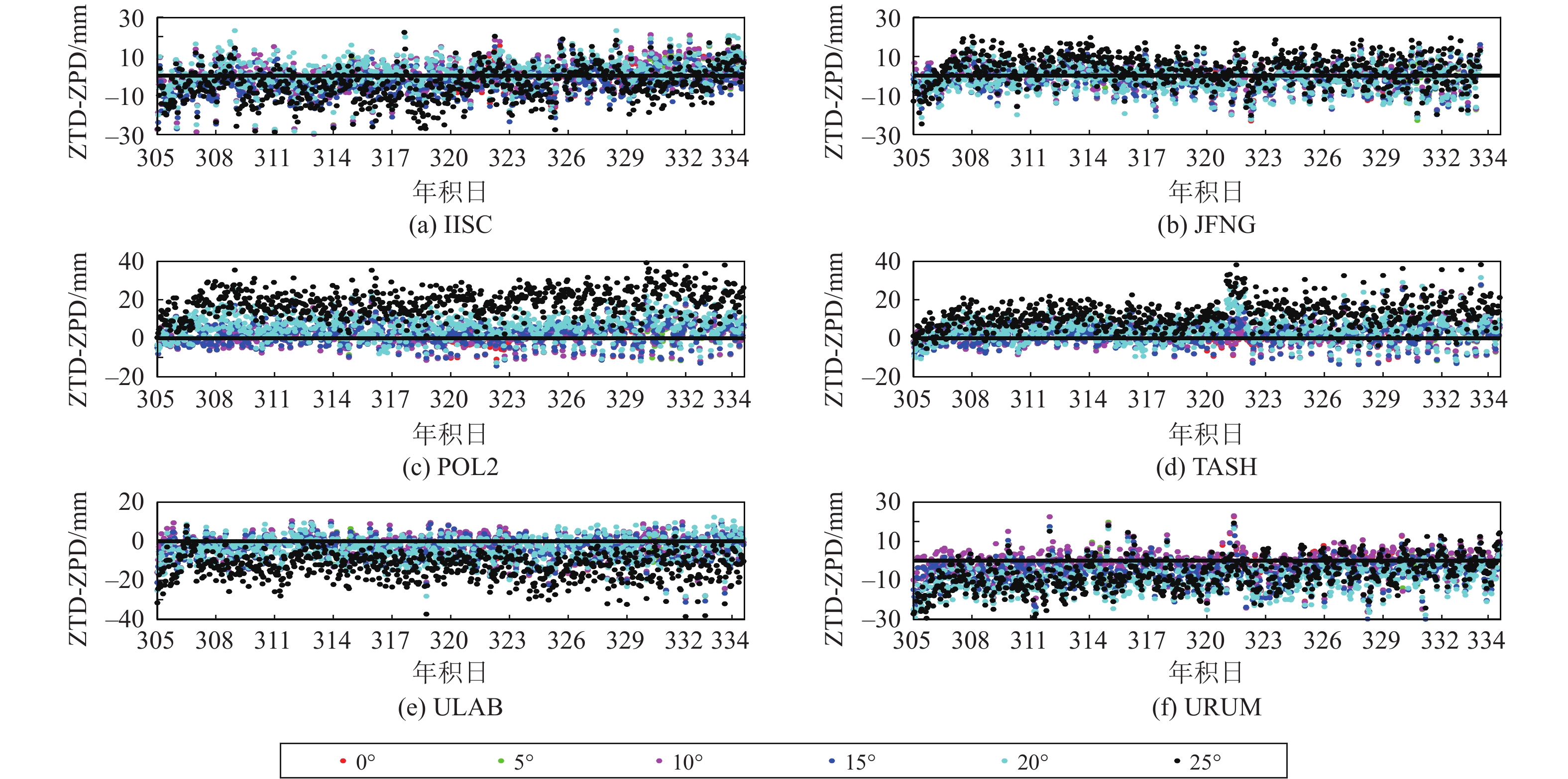
任超, 彭家頔, 佘娣, 等. 低高度角卫星信号对提高对流层估计精度的影响分析[J]. 大地测量与地球动力学, 2011, 31(6): 124-127. DOI: 10.14075/j.jgg.2011.06.010
|

Figures(13) / Tables(3)
Copyright © 2009《 GNSS World of China 》 Editorial Office
Address:84 Jianshe Dong Lu, Muye District, Xinxiang City, Henan Province, ChinaChina Pos:453000Tel:0373-3712411Fax:0373-3052232Email:qqdwxt@126.com
Supported by:
Beijing Renhe Information Technology Co. Ltd


 DownLoad: