GNSS World of China
GNSS World of China
| Citation: | LIU Guangming, HU Yu, SHA Feng, XIE Guojun, CHENG Wei. The digital twin earth fusioning BDS and GF[J]. GNSS World of China, 2022, 47(4): 39-45. doi: 10.12265/j.gnss.2022033

|

| [1] |
陈述彭. “数字地球”战略及其制高点[J]. 遥感学报, 1999, 3(4): 247-253. DOI: 10.11834/jrs.19990401
|
| [2] |
陈述彭. “数字鸿沟”与地球信息科学的应对[J]. 地球信息科学, 2003, 5(2): 1-2.
|
| [3] |
陈述彭. 从专题地图到数字地球——20世纪我国地图科技复兴的一角[J]. 测绘科学, 2008, 33(1): 5-6. DOI: 10.3771/j.issn.1009-2307.2008.01.001
|
| [4] |
承继成. 国家空间信息基础设施与数字地球[M]. 北京: 清华大学出版社, 1999.
|
| [5] |
承继成. 数字地球导论[M]. 北京: 科学出版社, 2000.
|
| [6] |
李德仁, 龚健雅, 邵振峰. 从数字地球到智慧地球[J]. 武汉大学学报(信息科学版), 2010, 35(2): 127-132.
|
| [7] |
龚健雅. 三维虚拟地球发展及应用[J]. 地理信息世界, 2011, 9(2): 15-17.
|
| [8] |
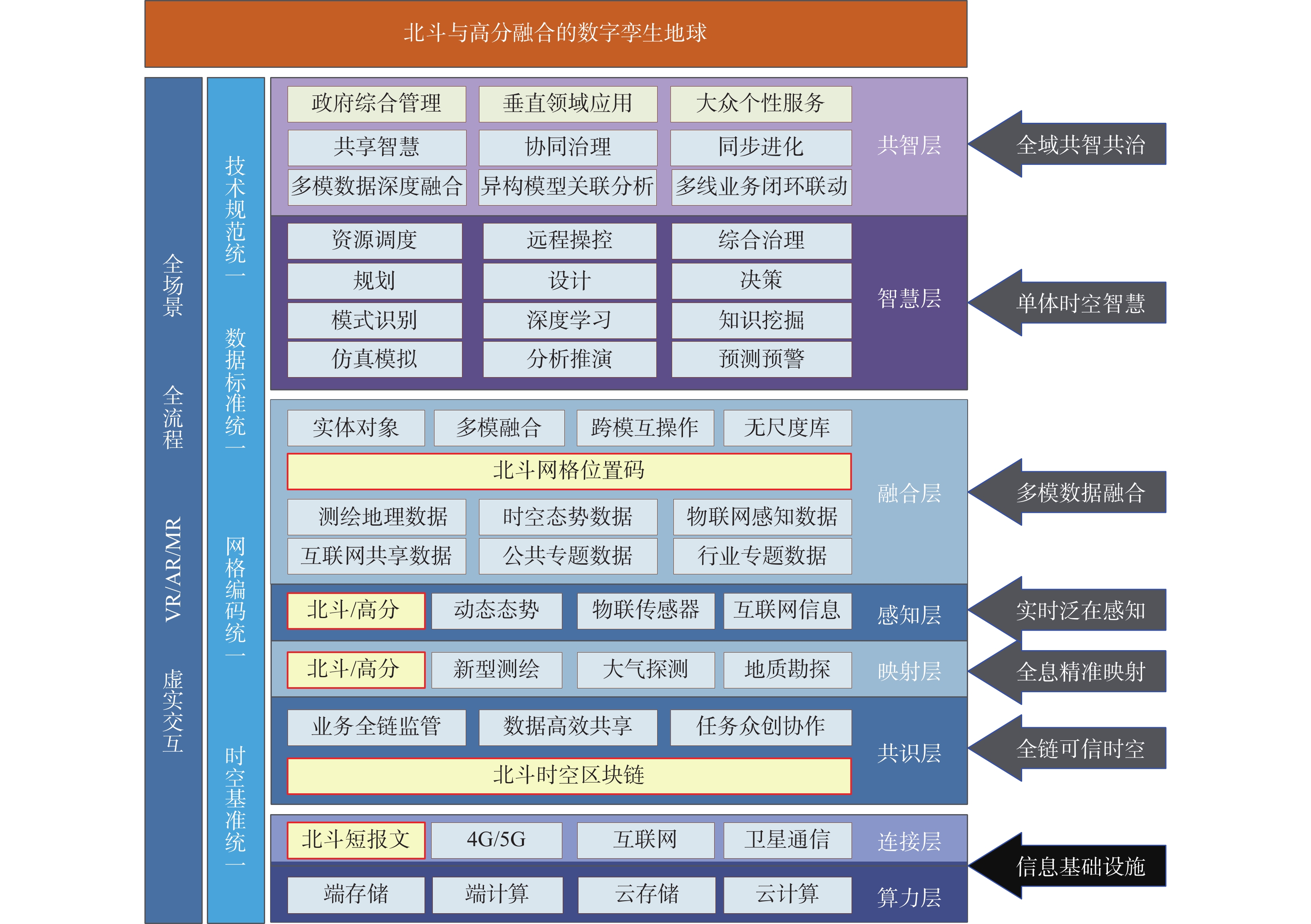
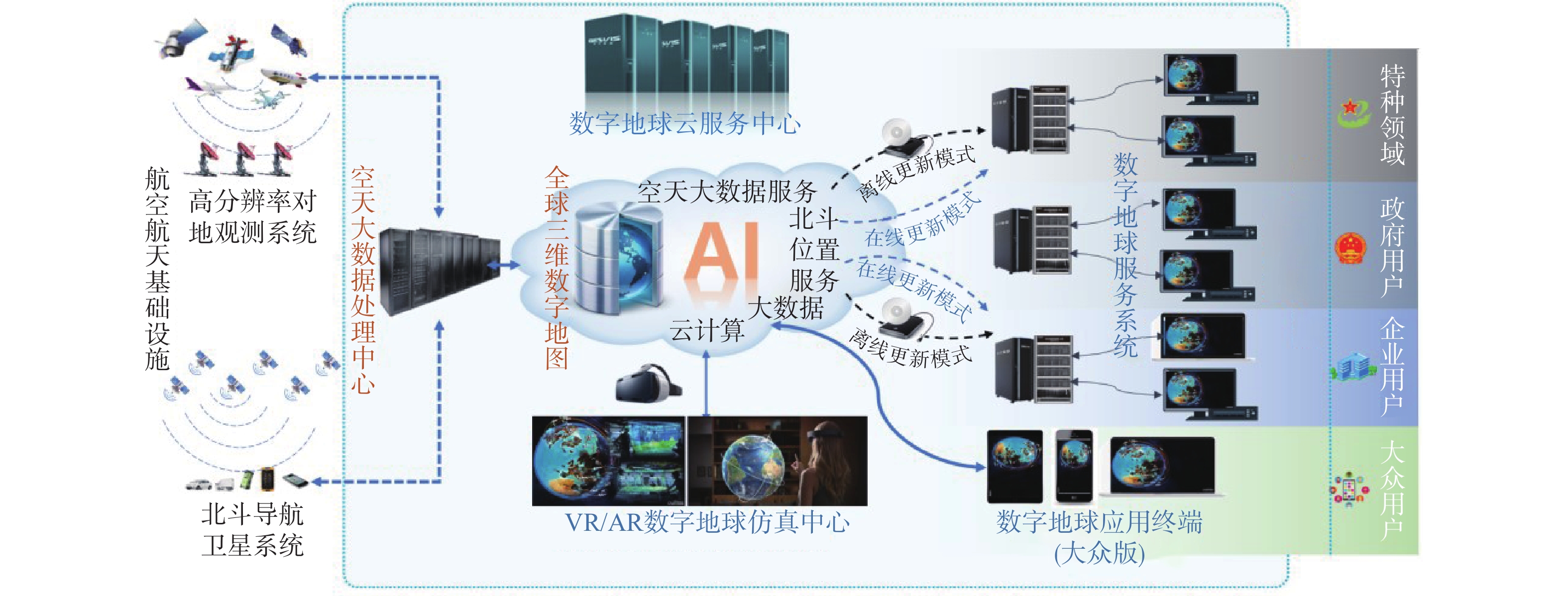
邵宗有. 构建北斗为体高分为象的数字孪生地球[R]. 第十一届中国卫星导航年会, 成都, 2020.
|
| [9] |
安世亚太科技股份有限公司. 数字孪生体技术白皮书[R]. 北京, 2019.
|
| [10] |
中国信息通信研究院. 数字孪生城市研究报告[R]. 北京, 2018.
|
| [11] |
中国信息通信研究院. 数字孪生城市白皮书[R]. 北京, 2021.
|
| [12] |
中国信息通信研究院. 数字孪生城市典型场景与应用案例[R]. 北京, 2021.
|
| [13] |
中国电子技术标准化研究院. 数字孪生应用白皮书[R]. 北京, 2020.
|
| [14] |
中国卫星导航定位协会. 中国卫星导航与位置服务产业发展白皮书[R]. 北京, 2021.
|
| [15] |
自然资源部科技发展司. 自然资源部卫星遥感应用报告(2019年) [R]. 北京, 2020.
|
| [16] |
陈锐志, 王磊, 李德仁, 等. 导航与遥感技术融合综述[J]. 测绘学报, 2019, 48(12): 1507-1522.
|
| [17] |
李文. 卫星通信、导航和遥感融合系统的关键技术研究[D]. 成都: 电子科技大学, 2016.
|
| [18] |
中国信息通信研究院. 区块链白皮书(2020年)[R]. 北京, 2020.
|
| [19] |
孙传恒, 于华竟, 徐大明, 等. 农产品供应链区块链追溯技术研究进展与展望[J]. 农业机械学报, 2021, 52(1): 1-13. DOI: 10.6041/j.issn.1000-1298.2021.01.001
|
| [20] |
周玉科. 利用区块链技术促进地球科学数据共享的思考: 概念与方案[J]. 测绘与空间地理信息, 2020, 43(9): 13-16.
|
| [21] |
傅易文晋, 陈华辉, 钱江波, 等. 面向时空数据的区块链研究综述[J]. 计算机工程, 2020, 46(3): 1-10.
|
| [22] |
王正涛, 姜卫平, 晁定波. 卫星跟踪卫星测量确定地球重力场的理论和方法[M]. 武汉: 武汉大学出版社, 2011.
|
| [23] |
国家测绘地理信息局. 大地测量控制点坐标转换技术规范. 测绘行业标准: CH/T 2014—2016[S]. 2016.
|
| [24] |
葛小三. 基于网格技术的空间知识发现与数据挖掘研究[J]. 武汉大学学报(信息科学版), 2006, 31(12): 1105-1107.
|
| [25] |
张静. 3D地球数据组织与网络传输优化方法[D]. 合肥: 合肥工业大学, 2014.
|
| [26] |
刘春雨. 基于数字地球的动态天空仿真与虚拟空战关键技术研究[D]. 成都: 电子科技大学, 2014.
|
| [27] |
董来稳. 基于数字地球的海量场景数据实时调度与绘制技术[D]. 成都: 电子科技大学, 2015.
|
Figures(2)
Copyright © 2009《 GNSS World of China 》 Editorial Office
Address:84 Jianshe Dong Lu, Muye District, Xinxiang City, Henan Province, ChinaChina Pos:453000Tel:0373-3712411Fax:0373-3052232Email:qqdwxt@126.com
Supported by:
Beijing Renhe Information Technology Co. Ltd


 DownLoad: