
GNSS World of China
GNSS World of China
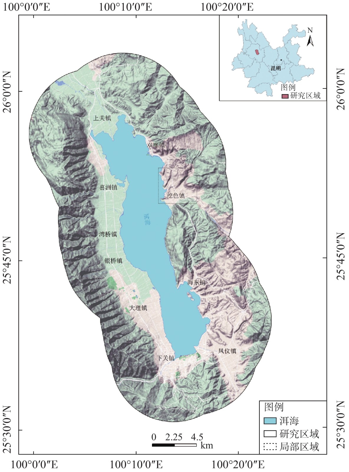
| Citation: | LI Xiaoxiang, HUANG Liang, LI Kai. Analysis of spatio-temporal change of land use around Erhai Lake from 1991 to 2020 based on GEE platform[J]. GNSS World of China, 2021, 46(5): 17-25. doi: 10.12265/j.gnss.2021041802

|

| [1] |
冯丁饶, 谢炘格, 雷昊仪, 等. 基于遥感技术与数学模型的土地利用/覆盖变化研究进展[J]. 湖北农业科学, 2018, 57(13): 5-9,12.
|
| [2] |
胡云锋, 商令杰, 张千力, 等. 基于GEE平台的1990年以来北京市土地变化格局及驱动机制分析[J]. 遥感技术与应用, 2018, 33(4): 573-583.
|
| [3] |
娄佩卿, 付波霖, 林星辰, 等. 基于GEE的1998—2018年京津冀土地利用变化对生态系统服务价值的影响[J]. 环境科学, 2019, 40(12): 5473-5483.
|
| [4] |
PHAN T N, KUCH V, LEHNERT L W. Land cover classification using google earth engine and random forest classifier—the role of image composition[J]. Remote sensing, 2020, 12(15): 2411. DOI: 10.3390/rs12152411
|
| [5] |
许泉立, 杨昆, 王桂林, 等. 基于蚁群算法的洱海流域土地利用变化模拟[J]. 农业工程学报, 2014, 30(19): 290-299,340.
|
| [6] |
王天山, 郑寒. 城市化过程中环洱海区域土地利用及景观格局变化分析[J]. 生态经济, 2016, 32(1): 181-185.
|
| [7] |
王涛, 张超, 于晓童, 等. 洱海流域土地利用变化及其对景观生态风险的影响[J]. 生态学杂志, 2017, 36(7): 2003-2009.
|
| [8] |
张磊, 武友德, 李君. 观景公路沿线土地利用变化特征分析——以大理洱海东环海路为例[J]. 长江流域资源与环境, 2018, 27(12): 2707-2717.
|
| [9] |
LIU, C C, ZHANG Y C, CHEN PY, et al. Clouds classification from sentinel-2 imagery with deep residual learning and semantic image segmentation[J]. Remote sensing, 2019, 11(2): 119. DOI: 10.3390/rs11020119
|
| [10] |
BREIMAN L. Random forests[J]. Machine learning, 2001, 45(1): 5-32. DOI: 10.1023/A:1010933404324
|
| [11] |
王猛, 张新长, 王家耀, 等. 结合随机森林面向对象的森林资源分类[J]. 测绘学报, 2020, 49(2): 235-244.
|
| [12] |
RODRIGUEZ-GALIANO V F, GHIMIRE B, ROGAN J, et al. An assessment of the effectiveness of a random forest classifier for land-cover classification[J]. Isprs journal of photogrammetry and remote sensing, 2012(67): 93-104. DOI: 10.1016/j.isprsjprs.2011.11.002
|
| [13] |
赵丹平, 顾海燕, 贾莹. 机器学习法在面向对象影像分类中的对比分析[J]. 测绘科学, 2016, 41(10): 181-186.
|
| [14] |
王李娟, 孔钰如, 杨小冬, 等. 基于特征优选随机森林算法的农耕区土地利用分类[J]. 农业工程学报, 2020, 36(4): 244-250.
|
| [15] |
徐新良, 刘纪远, 张树文, 等. 中国多时期土地利用土地覆被遥感监测数据集(CNLUCC)[DS/OL]. [2021-04-01]. 据注册与出版系统, 2018. DOI: 10.12078/2018070201.
|
| [16] |
唐常春, 李亚平. 多中心城市群土地利用/覆被变化地学信息图谱研究——以长株潭城市群为例[J]. 地理研究, 2020, 39(11): 2626-2641.
|
| [17] |
段群滔, 罗立辉. 人类活动强度空间化方法综述与展望——以青藏高原为例[J]. 冰川冻土, 2021, 43(1): 1-12.
|
| [18] |
严恩萍, 林辉, 王广兴, 等. 1990—2011年三峡库区生态系统服务价值演变及驱动力[J]. 生态学报, 2014, 34(20): 5962-5973.
|
| [19] |
南箔, 杨子寒, 毕旭, 等. 生态系统服务价值与人类活动的时空关联分析——以长江中游华阳河湖群地区为例[J]. 中国环境科学, 2018, 38(9): 3531-3541.
|
Figures(4) / Tables(4)
Copyright © 2009《 GNSS World of China 》 Editorial Office
Address:84 Jianshe Dong Lu, Muye District, Xinxiang City, Henan Province, ChinaChina Pos:453000Tel:0373-3712411Fax:0373-3052232Email:qqdwxt@126.com
Supported by:
Beijing Renhe Information Technology Co. Ltd


 DownLoad:


