GNSS World of China

2021 Vol. 46, No. 2

Display Method:
Cover
Indoor location algorithm of TDOA based on 5G
LI Fangxin, TU Rui, HAN Junqiang, ZHANG Yin, HONG Ju
2021, 46(2): 1-6. doi: 10.12265/j.gnss.2021012901
Abstract:
With the coming of the 5th-Generation (5G) era, 5G technology represented by millimeter wave communication has been paid more and more attention. 5G millimeter wave signal has larger bandwidth, higher frequency, shorter delay and sparser channel, so it can provide time estimation for time of arrival (TOA) and time difference of arrival (TDOA) positioning more accurately, which is conducive to achieve high-precision indoor positioning. In this paper, three kinds of indoor 5G millimeter wave TDOA positioning algorithms are compared and studied, and the results of indoor static and dynamic positioning results are calculated with Kalman filtering. The results show that the indoor static positioning accuracy based on 5G millimeter wave can reach 0.2886 m, and the dynamic positioning accuracy can reach 0.6076 m.
Analysis on the influence of angle measurement error of airborne early warning radar on detection track
YAO Huafei, XING Tao, LU Weihong
2021, 46(2): 7-12. doi: 10.12265/j.gnss.2020102301
Abstract:
Aiming at the problem of large track deviation detected by airbone warning radar system in the turning period of airbone early warning aircraft during test flight, the coordinate transformation model of the attitude of the aircraft, the angle of early warning radar and the detection track data was established, and the influence mechanism of track deviation was analyzed. Firstly, the relationship between the platform attitude change and the projected position of the detection target is analyzed in the case of angle measurement error of the early warning radar system, the coordinate transformation matrix is established, and the simulation program is written. Then, the actual flight data is used for simulation operation, and the simulation results are consistent with the actual detection of the early warning radar. The analysis results prove that the main causes of the track deviation is systematic error of angle measurement, clarify the error transmission path, and help to promote the development and improvement of airborne early warning radar system.
Precise point positioning time transfer based on receiver clock offsets constraint
ZHAO Chuanbao, SHENG Chuanzhen, ZHANG Baocheng
2021, 46(2): 13-17. doi: 10.12265/j.gnss.2020120901
Abstract:
Precise point positioning (PPP) was originally developed for positioning and navigation applications. Recently it has gradually been accepted as an effective tool for non-positioning applications such as time transfer. Nowadays, more and more stations use the high stability Hydrogen atomic clock to provide datum of time and frequency. However, receiver clock offsets are generally regarded as white noise parameters in customary PPP time transfer method, which does fully utilize the high stability of Hydrogen masers. Therefore, we calculate the empirical variance of H-masers based on real GPS observations, and proposed a constraint method of receiver clock offsets between adjacent epochs to improve the performance of PPP time transfer. We confirm this model by three time links experiment. The results imply that, compared with the customary PPP time transfer method, our method has higher stability and the short-term stability can increase up to one order of magnitude.
Fault tolerance technology on INS/GNSS/ODO embedded system
ZHANG Fangning, JIANG Jinguang, YAN Peihui, XIE Dongpeng, TAO Yifeng
2021, 46(2): 18-24. doi: 10.12265/j.gnss.2020110302
Abstract:
Aiming at the problem that the reliability of the low-cost embedded integrated navigation system is easily affected by various sensor failures and environment, a two-level fault detection and processing method is proposed based on inertial navigation system/GNSS/Odometer (INS/GNSS/ODO) robust integrated navigation algorithm with multiple Global navigation satellite system(GNSS)states. The first level detection uses the residual chi square test method based on analytic redundancy, and the second level test uses the improved dual state propagation chi square test algorithm use the self-developed GN310 low-cost embedded system to collect drive test data. The results show that the horizontal positioning accuracy is improved by 39.7% compared with the traditional algorithm. In addition, in the hardware in the loop simulation, the horizontal positioning error is kept within 3 m, which shows that the fault-tolerant method can effectively deal with ODO, mechanical arrangement fault and GNSS soft fault.
Study on the influence of ocean tidal load on precise point positioning
LI Yanhong, CHENG Fang, SHEN Pengli, XIAO Xia
2021, 46(2): 25-31. doi: 10.12265/j.gnss.2020090401
Abstract:
A total of 85 IGS stations located inland, on the coast and on the islands are selected from around the world, and the position of these stations are solved by considering adding the global ocean tide model (GOT4.8) or not. The effect of ocean tidal load on the precise point positioning(PPP) accuracy of IGS stations in different geographical regions is analyzed and studied. The results show that ocean tidal load has the greatest impact on the station located on the island. After adding the ocean tide correction, about 91% of the positioning error of the island stations are improved, and the proportions of coastal stations and inland stations are about 85% and 82%, respectively. The ocean tide correction has almost no impact on the N direction of the station, and has little impact on the E direction, and has the greatest positive impact on the U direction. Among them, the impact range in the U direction of the island station is 2~8 mm, and that of some stations are close to the centimeter level.
Multi-beam anti-jamming method for satellite navigation signals based on dynamic clustering
ZHENG Yaping, ZHAO Lulu, GONG Wenbin, SHAO Fengwei, CHANG Jiachao
2021, 46(2): 32-36. doi: 10.12265/j.gnss.2021020401
Abstract:
In response to the anti-jamming requirements of satellite navigation, multi-beam anti-jamming technology based on adaptive beam forming is studied. In order to solve the problem that the traditional fixed multi-beam anti-jamming method cannot consider all the navigation satellite signals to reduce the receiving performance when the number of beams is limited, a dynamic multi-beam anti-jamming method based on the K-means clustering algorithm is proposed. The antenna array is established for simulation, and the results show that the anti-jamming performance of this method is better than the traditional method when the number of Beidou satellite signals received is more than the number of beams.
BDS-3 precision analysis of precise point positioning
CHEN Zhezheng, OUYANG Mingjun, ZHU Xiangwei, DAI Zhiqiang, FU Qixiang
2021, 46(2): 37-43. doi: 10.12265/j.gnss.2020112701
Abstract:
The construction of the third-generation of Chinese BeiDou navigation system (BDS-3) was officially completed the construction on July 31, 2020. The BDS-3 provided new signals, B1C and B2a. Combining with B1I, B2I, and B3I signals from the second-generation of Chinese BeiDou novigation system (BDS-2), the article formed seven ionosphere-free combinations between different frequency to conduct dual frequency Precise Point Positioning (PPP) research. Results show that the positioning accuracy of all PPP combinations is on the order of centimeters.
Analysis of the influence of BDS-2 constellation on BDS-3 pseudo-range single point positioning accuracy
WANG Hanmin
2021, 46(2): 44-48. doi: 10.12265/j.gnss.2020082504
Abstract:
In view of the current BDS-2/BDS-3 integrated positioning performance, this paper analyzes the impact of different types of BDS-2 satellites on the accuracy of B1I, B3I, B1I/B3I pseudo range single point positioning accuracy of BDS-2/BDS-3 tracking station. It is found that different types of BDS-2 constellation satellites can effectively improve the visibility and geometry of BDS-3 satellite. GEO IGSO and MEO can improve BDS-3 single frequency and dual frequency pseudo range single point positioning accuracy within 20%, while all BDS-2 satellites can improve BDS-3 single frequency and dual frequency pseudo range single point positioning accuracy within 30%. The overall improvement relationship is all BDS-2 satellites > IGSO > GEO > MEO.
Comparative evaluation of navigation enhancement performance of typical LEO satellite systems
JIANG Xudong, CHEN Xiao, MA Manshuai, WANG Ying, LIANG Renteng, YANG Zijia
2021, 46(2): 49-55. doi: 10.12265/j.gnss.2020111202
Abstract:
In this paper, three typical low earth out satellite constellations which are Iridium NEXT system abroad, "Hongyan" constellation and "CentiSpace" of China, were selected to analyze the navigation enhancement of Beidou navigation satellite system (BDS) from the aspects of signal free space transmission loss, number of visible satellites and dilution of precision. The results show that the enhancement ability of LEO constellations to navigation system are different due to different constellation structure and number of satellites. As polar orbit constellations, Iridium NEXT system and "Hongyan" constellation have strong navigation enhancement ability in polar regions, but with the decrease of latitude, the enhancement ability decreases obviously. While the "CentiSpace" with inclined orbit as the main part has stronger navigation enhancement ability in middle and low latitudes.
Research on the difference of noise characteristics before and after earthquake based on GPS time series analysis
YANG Dengke
2021, 46(2): 56-61, 92. doi: 10.12265/j.gnss.2020100905
Abstract:
According to the fact that there is no enough research of the noise characteristics in the study of earthquake prediction, this paper analyze the influence of large earthquake on the noise characteristics of time series. Focusing on the large earthquake and the corresponding station nearby, the GPS time series were separated to five periods, before the earthquake 4~3 years, 3~2 years, 1~0 years, after the earthquake 0~1 years and 1~2 years. The spectral index of each period. Noise analysis was implemented using different noise model combination. Analysis results shows that, the change of spectral index, velocity field, amplitude and phase before and after the earthquake is very big, and the noise characteristics of GPS time series are significant to seismic response; For part of the stations the spectral index, velocity field and anniversary amplitude before and after the earthquake is consistent compare with results of the 1~0 years before the earthquake. In earthquake incubation period, the proportion of flicker noise + white noise(FN+WN) increased. And the noise component FN in flicker noise + random walk noise+ white noise(FN+RWN+WN) increased among all the noise components. All the ratio decreased after the earthquake, which is in consistent of the earthquake energy releaseand restoration of the site more meat situation to normal status after the earthquake.
The influence of different satellite altitude angles on GPS/GLONASS/BDS/Galileo fusion positioning
QIN Jiqian, XU Ninghui, LIANG Yueji
2021, 46(2): 62-68. doi: 10.12265/j.gnss.2020102003
Abstract:
This paper studied the offects of different satellites elevation on GPS/GLONASS/BDS/Galileo (G+R+B+E) fusion positioning and corresponding model was established. Using global navigation satellite system (GNSS) data provided by MGEX(Multi-GNSS Experiment), the theoretical analysis and experiments showed that, combination of G+R+B+E increased the number of satellite used for positioning, and could ensure a relative large number of satellites and a good space geometric distribution structure. Satellites elevation had little effect on positioning result when the satellites of combined system reached a certain number. External error accuracy of G+R+B+E combination in 3D direction was improved when satellites elevation was larger than 30°.
Performance analysis of high precision kinematic positioning of GPS-RTK/UWB tight combination
WANG Shengliang, LIU Genyou, GAO Ming, CAO Shilong, XIAO Gongwei, ZHAO Wenhao
2021, 46(2): 69-76. doi: 10.12265/j.gnss.2020110603
Abstract:
To overcome the shortage that GPS-RTK can not obtain centimeter level high precision positioning results due to signal blockage, insufficient satellites number and other reasons under complicated environment, in this paper, the tightly combination of ultra-wide band (UWB) short-range high precision positioning system and RTK are studied to improve the precision of dynamic positioning under complicated environment. According to the principle of UWB, the mathematical model of GPS-RTK/UWB tight combination is presented, and the data processing flow is introduced in detail. The experimental results show that GPS-RTK/UWB tight combination can further improve the ambiguity fixed success rate and dynamic positioning precision compared with only GPS when the observation environment is well. In a complicated environment with a cut-off mask elevation angle of 40 degree, the ambiguity fixed success rate was significantly increased from 20.93% to 93.96%. The positioning precision of N and E directions are improved to centimeter level, and that of U directions is improved to decimeter level, which can still meet certain engineering measurement needs.
Research on positioning technology based on Iridium burst signal
CUI Zhiying, YUE Fuzhan, TIAN Run, ZHANG Shuangna
2021, 46(2): 77-85. doi: 10.12265/j.gnss.2020121503
Abstract:
Global Navigation Satellite System (GNSS) has weak landing signal and is vulnerable to interference, etc., while low-orbit satellite system has gradually become a research hotspot in the navigation field due to its high landing power, low signal space loss and good Doppler characteristics. Iridium is the only low orbit satellite system that has achieved global coverage. Its satellite time and location(STL) capabilities are mainly for the US military. The specific signal system and processing technology have not been publicly released. Through in-depth study and analysis of Iridium STL burst signal system, this paper proposes to realize non-cooperative navigation and positioning by using STL burst signal, and completes the verification of positioning algorithm by receiving STL burst signal. The result shows that the proposed algorithm can achieve positioning accuracy better than 100 m. The research results can provide a theoretical basis for the construction of China’s low-orbit navigation system and effectively promote the sustainable development of the next generation of satellite navigation system.
3D reconstruction method of single tower building based on tilt photography
WANG Xiaodong, YUE Junhong, CHEN Xingfang
2021, 46(2): 86-92. doi: 10.12265/j.gnss.2020092502
Abstract:
Aiming at the failure of building three-dimensional model due to irregular shape of single tower building, a three-dimensional reconstruction method of tower single building based on inclined photography technology is proposed. First, the consumption type multi rotor unmanned aerial vehicle equipped with a single lens camera is selected to obtain the number of multi view images by loop shooting. Then, the multi view image data is processed by ContextCapture software to construct the real three-dimensional model of tower building. Finally, the accuracy of the generated three-dimensional model is evaluated by using the field control points and texture details. The experiment shows that; the loop line aerial photography used to obtains the multi view image data to construct the three-dimensional model has high accuracy, less missing texture information and high integrity.
Multi-source pipeline information acquisition platform and application
WANG Tao, CAI Dongjian, ZHOU Wanghui, WANG Jiake
2021, 46(2): 93-97. doi: 10.12265/j.gnss.2020112702
Abstract:
Aiming the problems of traditional pipeline information collection methods relying on paper maps, hand-written information collection, low collection efficiency and complex project management, a multi-source pipeline information collection platform was studied. The platform combines mobile geographic information system (GIS) technology, GNSS technology and wireless network communication technology. It covers the modules including rapid release of geographic information based on slice map web services, data communication between multi-source GNSS equipment and mobile terminals, mobile system construction for cloud services and platform modular development and management, and automation of internal business mapping. A fast, accurate, and complete surveying and mapping geographic information collection mode is realized. Data sharing and collaboration during data collection are enhanced, and the intelligent management level of pipeline information collection and survey projects is also improved.
BDS application of offshore UUV path tracking
WU Ziyue, LI Eryang, WANG Ru
2021, 46(2): 98-103. doi: 10.12265/j.gnss.2020112704
Abstract:
In order to solve the problem of various deviations when unmanned underwater vehicle (UUV) navigates along a given path. A system combining STM32 and UM220-IV N module based on Beidou Navigation Satelite System (BDS) is designed and applied to the specific path tracking of unmanned underwater vehicle. The position coordinates, velocity and direction data of UUV collected by the BDS positioning module are sent to the upper computer through the single-chip microcomputer module. The upper computer compares the data with the given tracking path data, calculates the path deviation, and controls the UUV driving module to change the UUV motion direction, so as to achieve accurate tracking of the given path. At the same time, through the wireless communication module, the water quality information collected by the UUV path track and information acquisition module can be displayed on the upper computer interface of the shore based monitoring system in real time. The underwater experiments show that the accuracy of UUV path tracking is significantly improved, which provides a reference method for correcting the path tracking error of UUV.
Application of neural network in SINS/GPS combined positioning
CHU Chengtao, WU Jun
2021, 46(2): 104-110. doi: 10.12265/j.gnss.2020120802
Abstract:
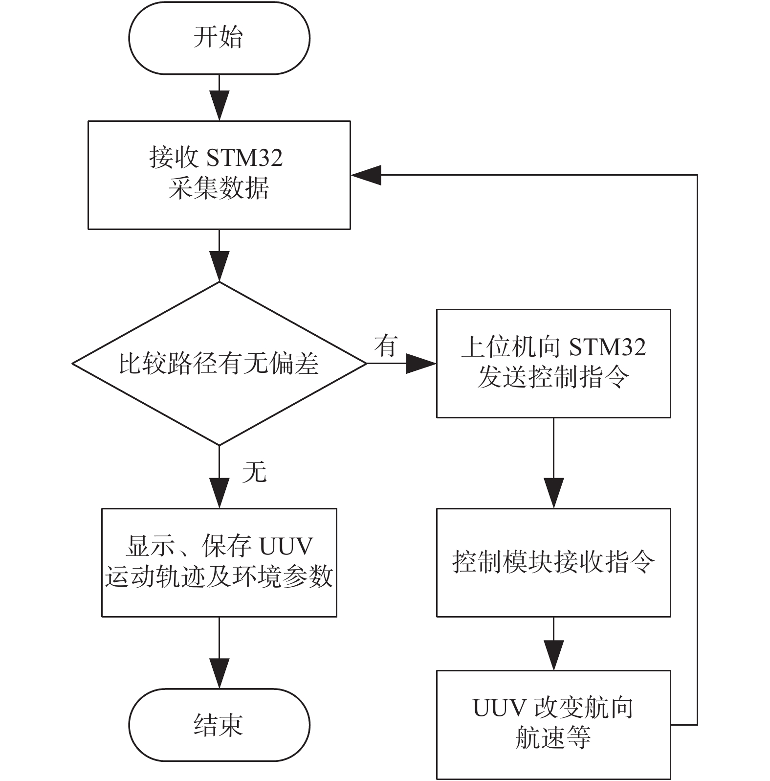
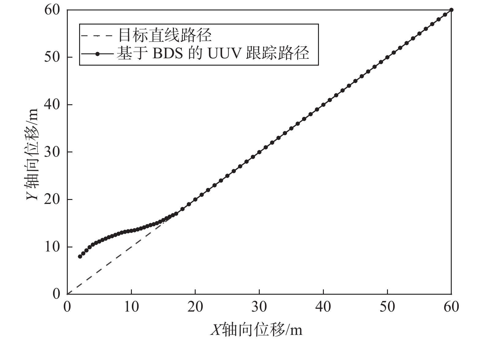
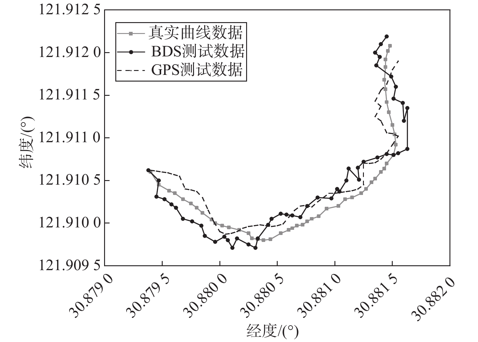
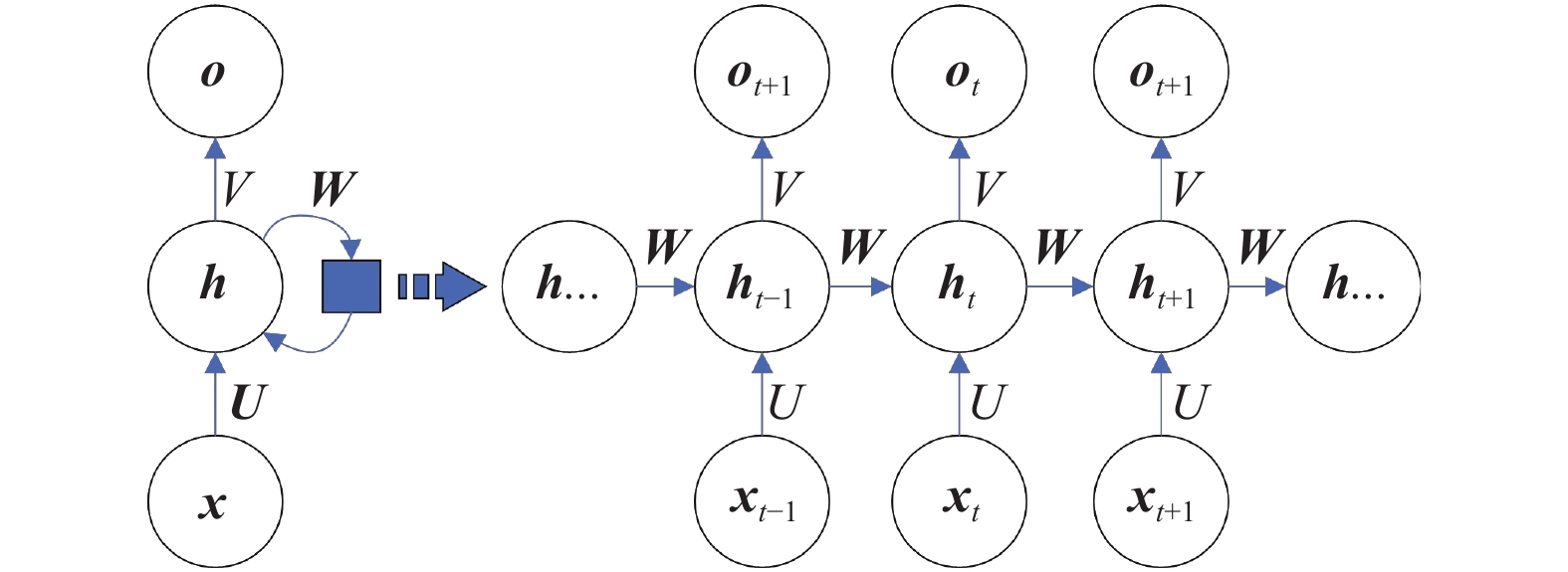
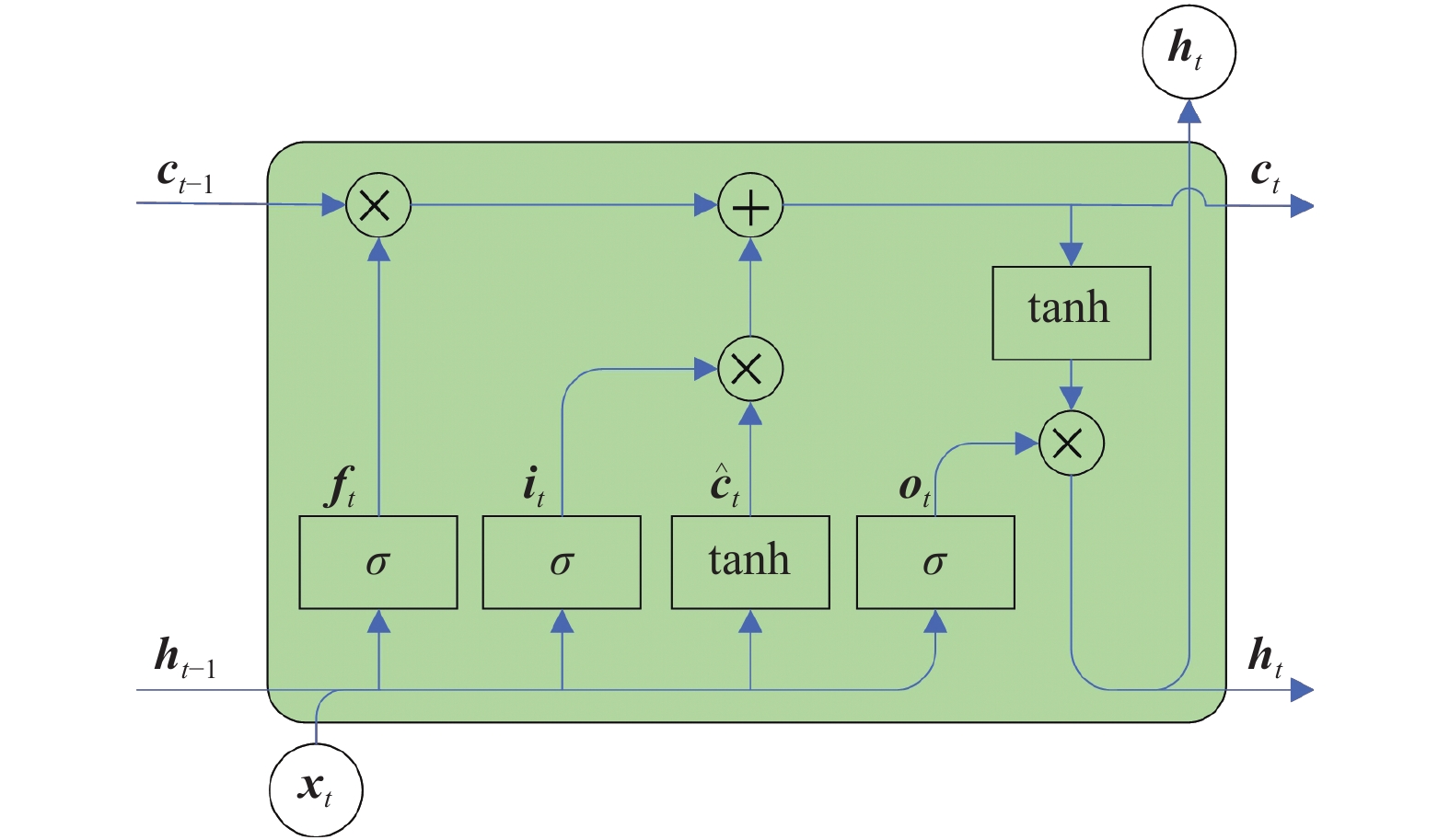
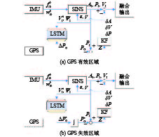
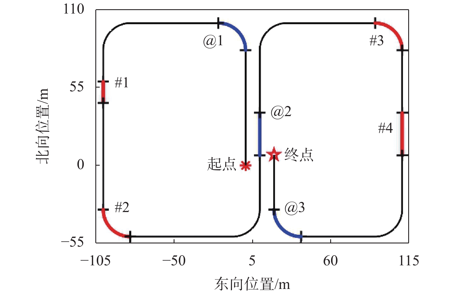
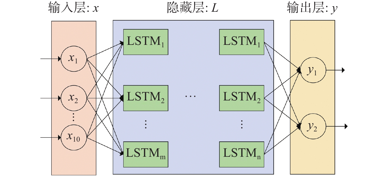
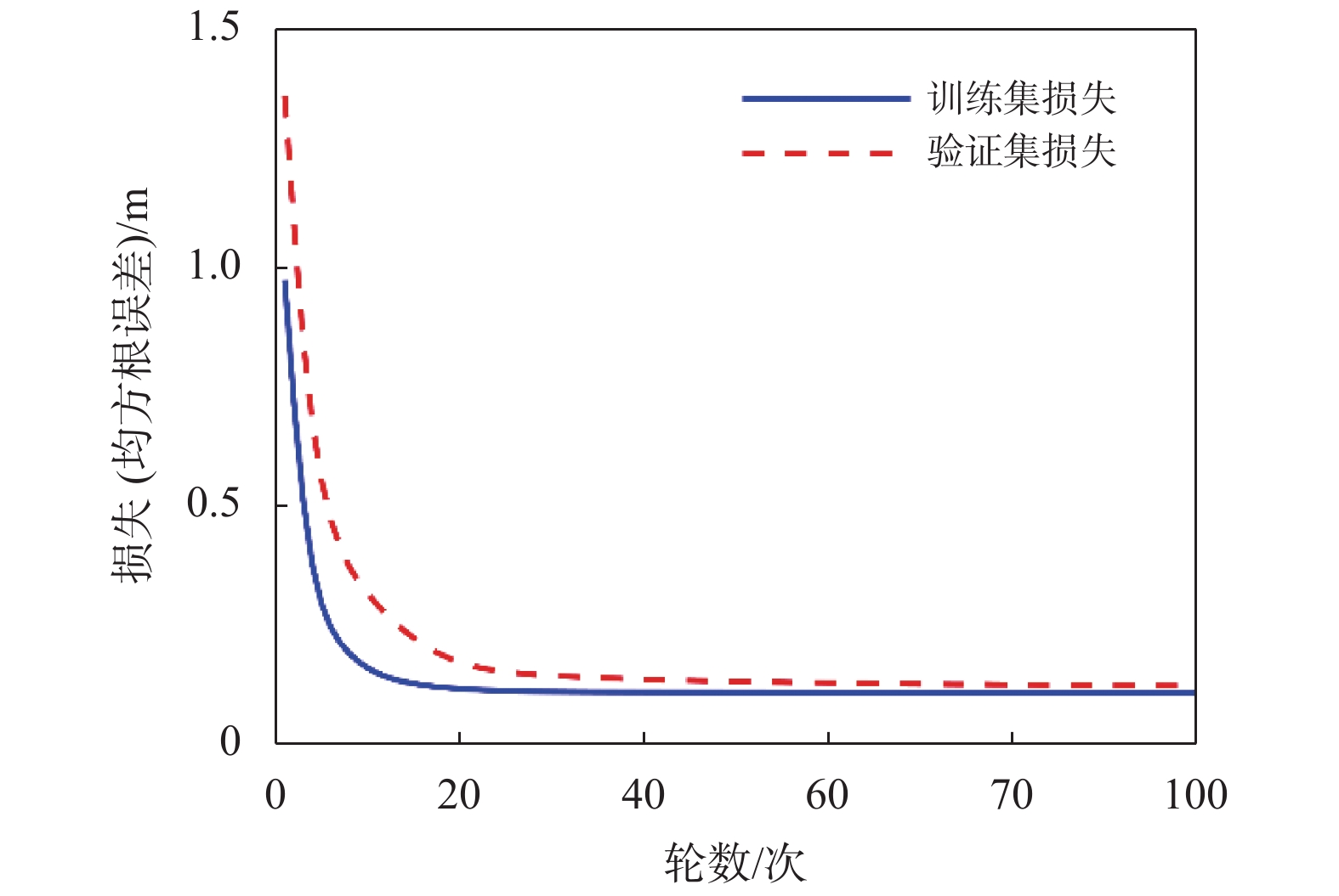
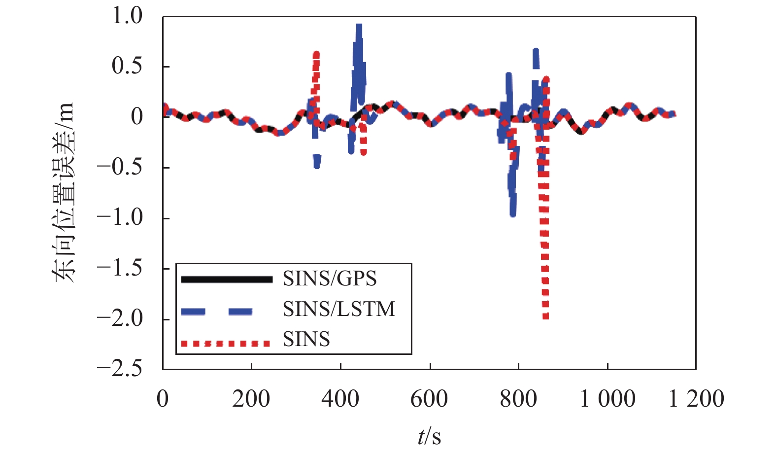
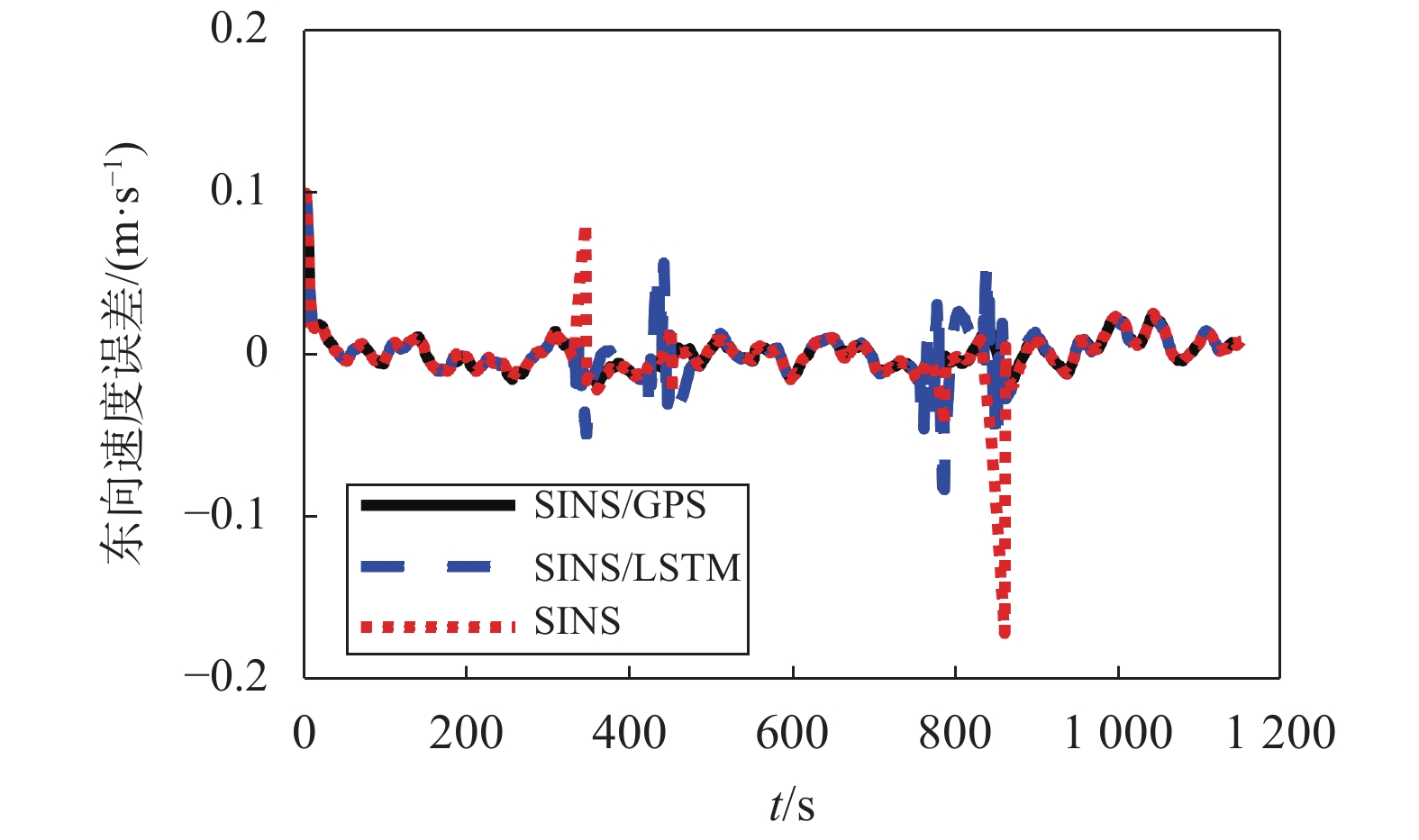
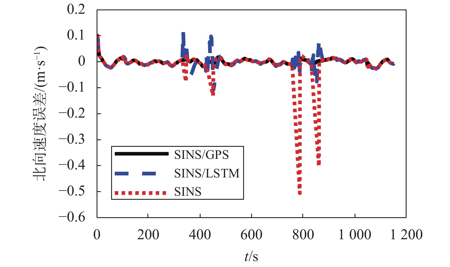
In cadastral surveying, a single system cannot meet the positioning requirements, and combined positioning technology has emerged. Among them, the strapdown inertial positioning system (SINS) and the GPS combined positioning are most widely used. In areas where satellite signals are interfered and failed, the system enters the pure SINS solution, and the positioning error will gradually accumulate and cannot meet the positioning accuracy requirements. In response to this problem, this paper proposes a combined positioning algorithm assisted by long and short-term memory (LSTM) neural network. According to the characteristics of LSTM neural network that can be effectively applied to long-distance time series, in the GPS effective area, the Kalman filtering (KF) algorithm is used to compare SINS/ GPS signal data fusion to obtain precise positioning information, while using inertial measurement unit (IMU), GPS and SINS output information is used to train the neural network; in the GPS failure area, the trained neural network to predict GPS location information is used, so that the system can continue filter with Kalman filter. Finally, combined with the characteristics of cadastral measurement, a simulation experiment was designed to prove that the algorithm can effectively suppress system error divergence and improve positioning accuracy when GPS signal fails, and it can still meet positioning accuracy requirements under different motion states with strong robustness.