

Research progress of GNSS-R water level monitoring and its application prospect in China’s water conservancy industry
-
摘要: 水位监测在水文学、水利工程、灾害防治等领域都具有非常重要的意义. 传统的水位监测方法存在成本高、覆盖范围小等缺点,GNSS不仅具有导航、定位及授时的功能,还可以利用其反射信号获取反射面的特性信息并将其称为全球卫星导航系统反射测量(Global Navigation Satellite System-Reflectometry,GNSS-R). 近年来,GNSS-R技术以低成本、全天候、高时空分辨率等优势为水位监测提供了一种新方法. 本文对GNSS-R水位监测的研究现状、不同方法的影响因素以及当前应用过程中存在的问题进行了总结归纳提出了下一步的发展趋势,最后对其在我国水利行业的应用进行了展望.
-
关键词:
- 全球卫星导航系统反射测量(GNSS-R) /
- 水位监测 /
- 群延迟 /
- 载波相位 /
- 信噪比(SNR)
Abstract: Water level monitoring is crucial for the fields of hydrology, hydraulic engineering, and disaster prevention and control. Traditional methods of monitoring water levels have several drawbacks, including high costs and limited coverage. The Global Navigation Satellite System (GNSS) serves multifaceted functions, including navigation, positioning, and timing. Additionally, it can harness its reflection signal to extract characteristic information from the reflecting surface, a technique known as GNSS reflection signal remote sensing (GNSS-R). In recent years, GNSS-R technology has emerged as a novel approach for water level monitoring, offering advantages such as cost-effectiveness, all-weather operability, and high temporal and spatial resolution. This paper provides a comprehensive review of the current state of research in GNSS-R water level monitoring. It discusses the influencing factors of different methodologies and identifies challenges encountered in the application process. Furthermore, it proposes future development trends and anticipates its potential application in China’s water conservancy industry.-
Key words:
- GNSS-R /
- water level monitoring /
- group delay /
- carrier phase /
- SNR
-
表 1 不同GNSS-R测高方法的对比
方法 天线配置 精度 优点 缺点 群延迟测高本地码测高 双天线 m 高时间分辨率 精度低、受水面粗糙度的影响 群延迟测高干涉测高(iGNSS-R) 双天线 dm 较高精度、高时间分辨率 设备和数据处理方法复杂、
受水面粗糙度的影响载波相位测高 双天线或多天线 cm 高精度、高时间分辨率 受水面粗糙度的影响 信噪比测高(GNSS-IR) 单天线 cm 简单易实现、不受水面粗糙度的影响 时间分辨率低  下载: 导出CSV
-
[1] ZARNIK M S, BELAVIC D. Study of LTCC-based pressure sensors in water[J]. Sensors and actuators, a physical, 2014, 220: 45-52. DOI: 10.1016/j.sna.2014.09.009 [2] POPA G N, POPA I, DINIŞ C M, et al. Resistive stepped transducer used for water level measurement[C]//Proceedings of the 1st WSEAS International Conference on Sensors and Signals, 2008: 66-71. [3] CHETPATTANANONDH K, TAPOANOI T, PHUKPATTARANONT P, et al. A self-calibration water level measurement using an interdigital capacitive sensor[J]. Sensors and actuators, a physical, 2014, 209(5): 175-182. DOI: 10.1016/j.sna.2014.01.040 [4] 许笠, 王延乐, 华小军. 雷达水位计在水情监测系统中的应用研究[J]. 人民长江, 2014, 45(2): 74-77. [5] TERZIC J, NAGARAJAH C R, ALAMGIR M. Fluid level measurement in dynamic environments using a single ultrasonic sensor and support vector machine (SVM)[J]. Sensors and actuators, a physical, 2010, 161(1-2): 278-287. DOI: 10.1016/j.sna.2010.05.005 [6] TABIBI S, FRANCIS O. Can GNSS-R detect abrupt water level changes[J]. Remote sensing, 2020, 12(21): 3614. DOI: 10.3390/rs12213614 [7] 朱德军, 李浩博, 王晓明. GNSS遥感技术在智慧水利建设中的应用展望[J] 水利水电技术(中英文), 2022, 53(10): 33-57.朱德军, 李浩博, 王晓明. GNSS遥感技术在智慧水利建设中的应用展望[J] 水利水电技术(中英文), 2022, 53(10): 33-57. [8] YU K, RIZOS C, BURRAGE D, et al. An overview of GNSS remote sensing[J]. EURASIP journal on advances in signal processing, 2014: 134. DOI: 10.1186/1687-6180-2014-134 [9] FOTI G, GOMMENGINGER C, JALES P, et al. Spaceborne GNSS reflectometry for ocean winds: first results from the UK TechDemoSat-1 mission[J]. Geophysical research letters, 2015(42): 5435-5441. DOI: 10.1002/2015GL064204 [10] CLARIZIA M P, RUF C, CIPOLLINI P, et al. First spaceborne observation of sea surface height using GPS-reflectometry[J]. Geophysical research letters, 2016, 43(2): 767-774. DOI: 10.1002/2015GL066624 [11] CERVELLERA F. GNSS-R as a source of opportunity for remote sensing of the cryosphere[J]. Computer science, geography, 2013. DOI: 10.5821/dissertation-2117-94934 [12] ZHANG Y, CHEN S S, HONG Z H, et al. Feasibility of oil slick detection using BeiDou-R coastal simulation[J]. Mathematical problems in engineering, 2017, 2017(2): 8098029. DOI: 10.1155/2017/8098029 [13] YANG Y, ZHENG Y, YU W K, et al. Deformation monitoring using GNSS-R technology[J]. Advances in space research, 2019, 63(10): 3303-3314. DOI: 10.1016/j.asr.2019.01.033 [14] CHEW C, SHAH R, ZUFFADA C, et al. Demonstrating soil moisture remote sensing with observations from the UK TechDemoSat-1 satellite mission[J]. Geophysical research letters, 2016, 43(7): 3317-3324. DOI: 10.1002/2016gl068189 [15] ZHENG N, CHEN P, LI Z. Accuracy analysis of ground-based GNSS-R sea level monitoring based on multi GNSS and multi-SNR[J]. Advances in space research, 2021, 68(4): 1789-1801. DOI: 10.1016/j.asr.2021.04.024 [16] MARTÍN-NEIRA M. A passive reflectometry and interferometry system (PARIS): application to ocean altimetry[J]. ESA journal, 1993, 17(4): 331-355. [17] WANG X L, HE X F, ZHANG Q. Evaluation and combination of quad-constellation multi-GNSS multipath reflectometry applied to sea level retrieval[J]. Remote sensing of environment, 2019, 231(2): 111229. DOI: 10.1016/j.rse.2019.111229 [18] XU L W, WAN W, CHEN X W, et al. Spaceborne GNSS-R observation of global lake level: first results from the TechDemoSat-1 mission[J]. Remote sensing, 2019, 11(12): 1438. DOI: 10.3390/rs11121438 [19] HA M C. Evolution of soil moisture and analysis of fluvial altimetry using GNSS-R[D]. University of Engineering and Technology, 2018. [20] SONG M F, HE X F, WANG X L, et al. Study on the quality control for periodogram in the determination of water level using the GNSS-IR technique[J]. Sensors (Basel, Switzerland), 2019, 19(20): 4524. DOI: 10.3390/s19204524 [21] 万玮, 李黄, 洪阳, 等. GNSS-R 遥感观测模式及陆面应用[J]. 遥感学报, 2015, 19(6): 882-893. [22] ZAVOROTNY V, GLEASON S, CARDELLACH E, et al. Tutorial on remote sensing using GNSS bistatic radar of opportunity[J]. Geoscience and remote sensing magazine, 2015, 2(4): 8-45. DOI: 10.1109/MGRS.2014.2374220 [23] 贺匀峤. 高精度GNSS-R海面测高基带信号处理研究[D].济南: 山东大学, 2022. [24] MARTIN-NEIRA, MANUEL, CAPARRINI, et al. The PARIS concept: an experimental demonstration of sea surface altimetry using GPS reflected signals[J]. IEEE transactions on geoscience and remote sensing, 2001, 39(1): 142-150. DOI: 10.1109/36.898676 [25] KATZBERG S J, GARRISON J L. Utilizing GPS to determine ionospheric delay over the ocean[J/OL]. (2023-08-23). Nasa TM, 1996: 4750. https://www.cs.odu.edu/~mln/ltrs-pdfs/NASA-96-tm4750.pdf [26] CARRENO-LUENGO H, CAMPS A, RAMOS-PEREZ I, et al. Experimental evaluation of GNSS-Reflectometry altimetric precision using the P(Y) and C/A signals[J]. IEEE journal of selected topics in applied earth observations and remote sensing, 2014, 7(5): 1493-1500. DOI: 10.1109/jstars.2014.2320298 [27] GAO F, XU T, WANG N, et al. A shipborne experiment using a dual-antenna reflectometry system for GPS/BDS code delay measurements[J]. Journal of geodesy, 2020, 94(9): 88. DOI: 10.1007/s00190-020-01421-4 [28] SEMMLING M. Altimetric monitoring of Disko Bay using interferometric GNSS observations on L1 and L2[D]. Deutsches GeoForschungsZentrum GFZ Potsdam, 2012. [29] MARTÍN-NEIRA M, D’ADDIO S, BUCK C, et al. The PARIS ocean altimeter in-orbit demonstrator[J]. IEEE Transactions on geoscience and remote sensing, 2011, 49(6): 2209-2237. DOI: 10.1109/TGRS.2010.2092431 [30] PURNELL D. Progress toward a practical GNSS-R water level sensor[M]. McGill University (Canada), 2022. [31] ESTEL C, RIUS A, MARTIN-NEIRAET M, et al. Consolidating the precision of interferometric GNSS-R ocean altimetry using airborne experimental data[J]. IEEE transactions on geoscience and remote sensing, 2014, 52(8): 4992-5004. DOI: 10.1109/TGRS.2013.2286257 [32] 王冬伟, 孙越强, 王先毅, 等. 一种基于北斗三号系统的GNSS-R海面干涉测高技术[J]. 空间科学学报, 2022, 42(3): 492-499. [33] 王娜子, 鲍李峰, 高凡. 逐历元GNSS-R测高单差和双差算法[J]. 测绘学报, 2016, 45(7): 795-802. [34] MARTIN-NEIRA M, COLMENAREJO P, SERRA G R C. Altimetry precision of 1 cm over a pond using the wide-lane carrier phase of GPS reflected signals[J]. Canadian journal of remote sensing, 2002, 28(3): 394-403. DOI: 10.5589/m02-039 [35] TREUHAFT R N, LOWE S T, ZUFFADA C, et al. 2-cm GPS altimetry over Crater Lake[J]. Geophysical research letters, 2001, 22(1): 4343-4346. DOI: 10.1029/2001GL013815 [36] LÖFGREN J S, HAAS R. Sea level measurements using multi-frequency GPS and GLONASS observations[J]. EURASIP journal on advances in signal processing, 2014, 2014(1): 50. DOI: 10.1186/1687-6180-2014-50 [37] HELM A. Ground-based GPS altimetry with the L1 OpenGPS receiver using carrier phase-delay observations of reflected GPS signals[D]. Deutsches GeoForschungsZentrum GFZ Potsdam, 2008. [38] LIU W, BECKHEINRICH J, SEMMLING M, et al. Coastal sea-level measurements based on GNSS-R phase altimetry: a case study at the onsala space observatory, sweden[J]. IEEE transactions on geoscience and remote sensing, 2017, 55(10): 5625-5636. DOI: 10.1109/TGRS.2017.2711012 [39] 沈思明. GNSS海面高度测量与误差分析[D]. 上海: 上海海洋大学, 2018. [40] FABRA F, CARDELLACH E, RIUS A, et al. Phase altimetry with dual polarization GNSS-R over sea ice[J]. IEEE transactions on geoscience and remote sensing, 2011, 50(6): 2112-2121. DOI: 10.1109/TGRS.2011.2172797 [41] HE Y Q, GAO F, XU T H, et al. Coastal altimetry using interferometric phase from GEO satellite in Quasi-Zenith satellite system[J]. IEEE geoscience and remote sensing letters, 2022(19). DOI: 10.1109/LGRS.2021.3068376 [42] KUCWAJ J-C, REBOUL S, STIENNE G. Circular regression applied to GNSS-R phase altimetry[J]. Remote sensing, 2017, 9(7): 651. DOI: 10.3390/rs9070651 [43] 苏晓容, 张云, 韩彦岭, 等. 岸基 GNSS 单天线潮位高度小波分析反演[J]. 导航定位学报, 2019, 7(4): 87-93. [44] BILICH A, LARSON K M. Mapping the GPS multipath environment using the signal-to-noise ratio(SNR)[J]. Radio science, 2007, 42(6): 6003. DOI: 10.1029/2007RS003652 [45] LARSON K M, LOEFGREN J S, HAAS R. Coastal sea level measurements using a single geodetic GPS receiver[J]. Advances in space research, 2013, 51(8): 1301-1310. DOI: 10.1016/j.asr.2012.04.017 [46] WILLIAMS S D P, BELL P S, MCCANN D L, et al. Demonstrating the potential of low-cost GPS units for the remote measurement of tides and water levels using interferometric reflectometry[J]. Journal of atmospheric and oceanic technology, 2020, 37(10): 1925-1935. DOI: 10.1175/JTECH-D-20-0063.1 [47] ZHANG S C, LIU K, LIU Q, et al. Tide variation monitoring based improved GNSS-MR by empirical mode decomposition[J]. Advances in space research, 2019, 63(10): 3333-3345. DOI: 10.1016/j.asr.2019.01.046 [48] STRANDBERG J, HOBIGER T, RÜDIGER HAAS. Improving GNSS-R sea level determination through inverse modeling of SNR data[J]. Radio science, 2016, 51(8): 1286-1296. DOI: 10.1002/2016RS006057 [49] WANG X L, ZHANG Q, ZHANG S C. Sea level estimation from SNR data of geodetic receivers using wavelet analysis[J]. GPS solutions, 2019, 23(1): 1-14. DOI: 10.1007/s10291-018-0798-7 [50] WANG X L, HE X F, XIAO R Y, et al. Millimeter to centimeter scale precision water-level monitoring using GNSS reflectometry: application to the south-to-north water diversion project, China[J]. Remote sensing of environment, 2021, 265: 112645. DOI: 10.1016/j.rse.2021.112645 [51] SEMMLING A M, WICKERT J, SCHO S, et al. A zeppelin experiment to study airborne altimetry using specular Global Navigation Satellite System reflections[J]. Radio science, 2013, 48(4): 427-440. DOI: 10.1002/rds.20049 [52] STRANDBERG J, HOBIGER T, HAAS R. Real-time sea-level monitoring using Kalman filtering of GNSS-R data[J]. GPS solutions, 2019, 23(3): 1-12. DOI: 10.1007/s10291-019-0851-1 [53] 陈昊晟. 基于多系统GNSS-IR监测长江上游巴东水位变化的研究[D]. 南京: 南京信息工程大学, 2022. [54] GAO F, XU T H, WANG N Z, et al. Spatiotemporal evaluation of GNSS-R based on future fully operational Global Multi-GNSS and eight-LEO constellations[J]. Remote sensing, 2018, 10(2): 67. DOI: 10.3390/rs10010067 [55] CLARIZIA M P, RUF C S. On the spatial resolution of GNSS reflectometry[J]. IEEE geoscience and remote sensing letters, 2016, 13(8): 1064-1068. DOI: 10.1109/LGRS.2016.2565380 [56] MARTIN, F, CAMPS A, FABRA F et al. Mitigation of direct signal cross-talk and study of the coherent component in GNSS-R[J]. Geoscience and remote sensing letters, 2015, 12(2): 279-283. DOI: 10.1109/LGRS.2014.2335772 [57] MUNOZ-MARTIN J F, ONRUBIA R, ONRUBIA R, et al. Untangling the incoherent and coherent scattering components in GNSS-R and novel applications[J]. Remote sensing, 2020, 14(7): 1208. DOI: 10.3390/rs12071208 [58] CAMPS A, MUNOZ-MARTIN J F. Analytical computation of the spatial resolution in GNSS-R and experimental validation at L1 and L5[J]. Remote sensing, 2020, 12(23): 3910. DOI: 10.3390/rs12233910 [59] CAMPS A. Spatial resolution in GNSS-R under coherent scattering[J]. IEEE geoscience and remote sensing letters, 2019, 17(1): 32-36. DOI: 10.1109/LGRS.2019.2916164 [60] ROESLER C, LARSON K M. Software tools for GNSS interferometric reflectometry (GNSS-IR)[J]. GPS solutions, 2018, 22(3): 80. DOI: 10.1007/s10291-018-0744-8 [61] LARSON K M, RAY R D, NIEVINSKI F G, et al. The accidental tide gauge: a GPS reflection case study from kachemak bay, alaska[J]. IEEE geoscience and remote sensing letters, 2013, 10(5): 1200-1204. DOI: 10.1109/LGRS.2012.2236075 [62] LOEFGREN J S, HAAS R, SCHERNECK H G. Sea level time series and ocean tide analysis from multipath signals at five GPS sites in different parts of the world[J]. Journal of geodynamics, 2014(80): 66-80. DOI: 10.1016/j.jog.2014.02.012 [63] ROUSSEL N, FRAPPART F, RAMILLIEN G, et al. Simulations of direct and reflected wave trajectories for ground-based GNSS-R experiments[J]. Geoscientific model development, 2014, 7(5): 2261-2279. DOI: 10.5194/gmd-7-2261-2014 [64] SANTAMARIA-GOMEZ A, WATSON C, GRAVELLE M, et al. Levelling co-located GNSS and tide gauge stations using GNSS reflectometry[J]. Journal of geodesy, 2015, 89(3): 241-258. DOI: 10.1007/s00190-014-0784-y [65] SANTAMARÍA-GÓMEZ A, WATSON C. Remote leveling of tide gauges using GNSS reflectometry: case study at spring bay, Australia[J]. GPS solutions, 2017, 21(2): 451-459. DOI: 10.1007/s10291-016-0537-x [66] WILLIAMS S D P, NIEVINSKI F G. Tropospheric delays in ground-based GNSS multipath reflectometry-experimental evidence from coastal sites[J]. Journal of geophysical research solid earth, 2017, 122(3): 2310-2327. DOI: 10.1002/2016JB013612 [67] LUBEIGT C, ORTEGA L, VILÀ-VALLS J, et al. On the impact and mitigation of signal crosstalk in ground-based and low altitude airborne GNSS-R[J]. Remote sensing, 2021, 13(6): 1085. DOI: 10.3390/rs13061085 [68] ONRUBIA R, PASCUAL D, PARK H, et al. Satellite cross-talk impact analysis in airborne interferometric Global Navigation Satellite System-Reflectometry with the microwave interferometric reflectometer[J]. Remote sensing, 2019, 11(9): 1120. DOI: 10.3390/rs11091120 [69] PASCUAL D, PARK H, ONRUBIA R, et al. Crosstalk statistics and impact in interferometric GNSS-R[J]. IEEE journal of selected topics in applied earth observations and remote sensing, 2016, 9(10): 4621-4630. DOI: 10.1109/JSTARS.2016.2551981 [70] HE Y Q, XU T H, GAO F, et al. Analysis and mitigation of crosstalk effect on coastal GNSS-R code-level altimetry using L5 signals from QZSS GEO[J]. Remote sensing, 2021, 13(22): 4553. DOI: 10.3390/rs13224553 [71] WANG Y, MORTON Y J. Coherent GNSS reflection signal processing for high-precision and high-resolution spaceborne applications[J]. IEEE transactions on geoscience and remote sensing, 2020, 59(1): 831-842. DOI: 10.1109/TGRS.2020.2993804 [72] WANG Q, ZHENG W, WU F, et al. A new GNSS-R altimetry algorithm based on machine learning fusion model and feature optimization to improve the precision of sea surface height retrieval[J]. Frontiers in earth science, 2021(9): 730565. DOI: 10.3389/feart.2021.730565 -


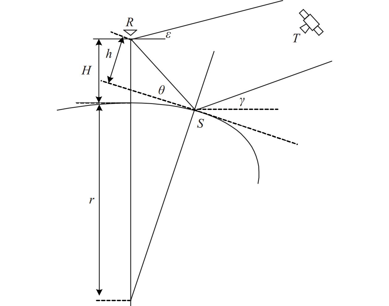

 点击查看大图
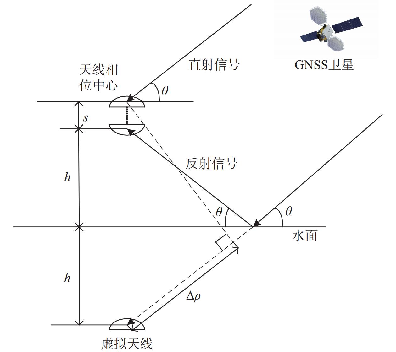
图(4) / 表(1)
计量
- 文章访问数: 225
- HTML全文浏览量: 40
- PDF下载量: 27
- 被引次数: 0
